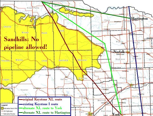
The Nebraska Department of Environmental Quality has mapped out the specific area around which TransCanada must reroute its proposed Keystone XL oil pipeline. The hope is that, if Keystone XL must be built, we can at least prevent TransCanada from turning the Nebraska Sandhills into the Tar Sandhills.
Here is the map from the NDEQ announcement, along with some potential pipeline routes:
 NDEQ drew the yellow Nebraska Sandhills region; I added the lines for pipeline routes. The red line shows (roughly) the original route TransCanada proposed for Keystone XL, the route across the Sandhills and the Ogallala Aquifer that raised hackles in Nebraska and earned it a delay for further environmental review from President Obama. The dark blue line shows (again, roughly) the route of the existing Keystone I pipeline (you know, the one that leaked 230 times more frequently than TransCanada predicted) through eastern Nebraska.
The green lines come entirely from my imagination. The light green line shows the shortest detour TransCanada could take from its entry point at the South Dakota&ndashNebraska border to skirt to Sandhills pipeline exclusion zones and reconnect with its original route at York, Nebraska. That route would require negotiating (or forcing through eminent domain) about 200 miles worth of new easement deals with new landowners. To reduce its hassles, TransCanada could choose the dark green route, which would stretch eastward from the original route about 120 miles to hook directly into the existing Keystone I pipeline near the Hartington pumping station. From there on down to Steele City, TransCanada could simply lay a second pipe along right-of-way it already owns.
TransCanada won't take that dark green route: at that big northward bend in the Missouri River, that green line runs into the Santee Sioux Reservation. TransCanada assiduously avoided drawing Keystone XL across Indian territory, and for good reason. But TransCanada has a very fluid definition of what's possible: TransCanada once said rerouting Keystone XL was impossible, only to come back less than a month later to say rerouting is quite easy. TransCanada may decide that crossing just one small reservation, or making one small bump in a detour, may be easier than risking running into a dozen more Randy Thompsons.
Folks in eastern Nebraska, watch out for the pipeline double-up option!
Update 12:36 CST: More Keystone XL reading:
- The Natural Resources Defense Council reminds us of six big reasons to just say no to Keystone XL.
- NRDC's Anthony Swift reminds us that Keystone XL is all about shipping oil out of North America.
- Jeff Goodell at Rolling Stone suggests that President Obama could triangulate on Keystone XL, approve it to curry favor with the labor unions backing the project, and tell the enviro wing to just be glad they got an arguably bigger victory on mercury emission rules.
- Donald Trump and Senator Roy Blunt, and others are promoting Keystone XL by repeating TransCanada's illusory job-creation claims. Lies, lies, lies!
- One Canadian commentator sees Keystone XL undermining efforts to diversify the Alberta economy and says Canada would do better to refine the oil at home rather than shipping it out for value-add in America.

Cory, I don't have a link, but I understand that recently the US has become a net exporter of petroleum products. If this is already the case, then surely we will be exporting even more once we get the additional Canaidian oil, yes?
Here's your link Bill.
http://www.washingtonpost.com/blogs/ezra-klein/post/americas-top-export-in-2011-was--fuel/2011/12/31/gIQAzlvgSP_blog.html
So bring on Keystone XL so we can export more. Wait. What...that's not US oil? It's not staying here in the US? They are using Russian steel?
No worries. John Thune thinks it's a good idea to eminent domain the property of US citizens so that we can risk our environment for Canadian companies.
Hazmat, EPA responding to oil leak in Idaho's Clearwater River:
http://www.bozemandailychronicle.com/ap_news/montana/article_77d8d971-e2a9-5709-91a0-83bb5ddadedf.html
Tribes:
"The American Civil Liberties Union in a 2009 report said that “South Dakota also used an alleged lack of Indian interest in state elections to justify denying residents of some counties the right to vote or run for county office.†In fact, one reason to get excited and engaged in the 2012 election is that many Republican-controlled state legislatures are trying to restrict voting or dilute American Indian votes."
http://www.marktrahant.com/www.marktrahant.com/Monday_post/Entries/2012/1/2_Winning_the_day__Indian_Country%E2%80%99s_year_begins_now.html