I sit safe and dry behind a computer well removed from the second hundred-year-flood to hit the Big Sioux–Missouri confluence in three years. From my safe perch, the most telling sign that this flood is serious is a single drastic action that Governor Dennis Daugaard is taking to fight it: he is closing Interstate 29 from Exit 26 (the Vermillion exit—sorry, Elk Point) south and turning the overpass at Exit 4 into a levee. That civil engineering project begins at noon Central today.
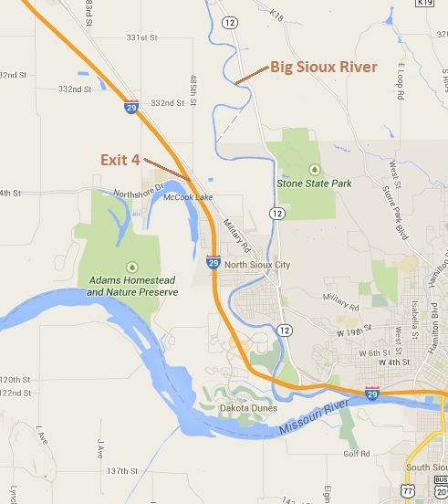
Let's look at the map:
Now let's zoom in on Exit 4:
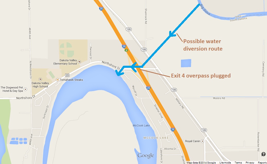
I hear from a source on the ground in Union County that the Big Sioux narrows somewhere near North Sioux City. At that narrowing, the approaching flood waters would rise, accelerate, and undermine whatever channel walls exist. The plan is thus to divert the flood waters before they reach that weak point, pour the excess water across I-29 into McCook Lake, and let it wash down to the Missouri.
Now check the satellite view:
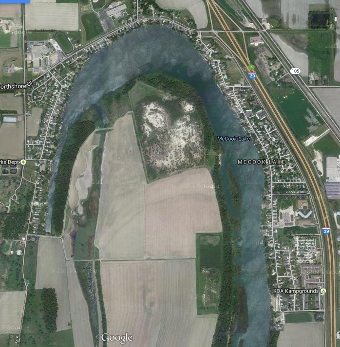
You can see all the houses next to McCook Lake. Those houses will get an unexpected front-porch view of the flood waters. My Union County source tells me those folks were instructed at yesterday's big public meeting at Dakota Valley High School, which is that large lot you see in the satellite photo on the northwest side of the lake, that they should be prepared to defend their homes from the flood waters.
Questions Number 1, 2, and 3 for folks around McCook Lake is, where do I get sandbags? (Dakota Valley Elementary School at 1150 Northshore Drive, right by McCook Lake, and 704 E. Rose Street in Elk Point.)
The next question: will this plan work? Take a look at Exit 4:
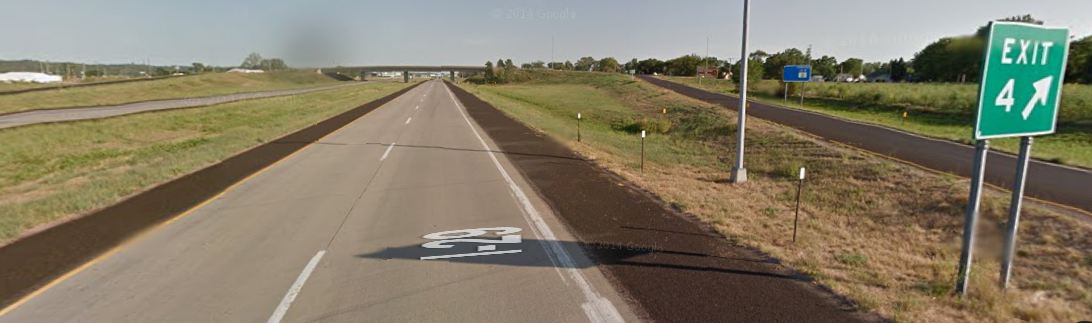
The Exit 4 levee is penned in by two long ramps. The water will need to move around both ramps to go where the state wants it to go. Plugging the overpass will create a large, skinny holding pond with a lot of water swirling, saturating and eating away at the southbound off-ramp. I invite any civil engineers not on duty to share their perspective on the best way to manage water flow at this site.
The next question is whether any of the state resources sandbagging the bridge will be made available to help McCook Lake residents defend their property. I know, it's an emergency, and we don't have time for lawyers. But the state is essentially taking private property around McCook Lake for a public purpose, saving the rest of North Sioux City from flood damage. I would assume that the state will either help minimize the damage to McCook Lake property or will be opening up the coffers to compensate those folks for their service to the greater good.
And the final economic question: do the numbers add up here? We are sacrificing one residential area to protect a larger, more populous zone that includes a lot of industry. But we are also diverting a river across a federal highway and putting a serious crimp in travel and commerce between South Dakota and Iowa for an indefinite period of time. Vermillion and Ponca will see a big boost in business from the detour (and State Highway 12 in Nebraska is beautiful), but we're adding a good 35 minutes to every trip from Sioux Falls to Sioux City. Multiply 35 minutes worth of labor and fuel by, say, seven days, and by about 11,000 regular vehicles and about 2,500 trucks, and you get a significant economic impact.
But the water's coming, and we can't stand here with our slide rules and backs of envelopes. We need to lay some sandbags and build some levees. Let's hope when the engineers get done, they can take a moment to show us the calculus they did to demonstrate that the plan under execution really is the smartest use of resources.
Update 11:05 CDT: The state provides detour maps and other flood information on its Disaster Recovery website:

Truckers headed from Sioux Falls to Omaha will be detoured to Albert Lea and Des Moines. That adds four hours and about 270 miles to the trip.
Rest assured damn few truckers will be taking the Des Moines-Albert Lee detour. They'll find shorter routes around the flooding.
This is the best idea they can come up with?
Good find,
This should make for entertaining reading/viewing.... I'm glad to be living on high-high ground....
Naturally this odd weather has nothing whatever to do with any type of climate change... nope, not possible.....
This isn't a solution for now, but in the future would it be better to rebuild the exit and have the local road go under the interstate? In situations like this (and maybe it will never happen again) I-29 would remain open and the local road could easily be turned into a diversion canal for the flood water running under the interstate.
Let's see how well the water flows in this project in the first place. I would think it would be easier to dredge or widen or bulk up the levee in the existing Sioux River channel rather than creating a permament solution that promises repeated disruptions of interstate traffic.
It adds 4 hours 8 min and 279.4 miles if you don't run into any rain/flooding delays in iowa.
I see lawsuits if homes there are damaged with this plan. More than one state will be responsible and sued.
Could be DD's Waterloo.
http://lb.511ia.org/ialb/roadreports/routeselect.jsf
According to this from 511ia.org there sre some lane closures on Interstates 35 and 8o from Albert Lea to Omaha.
Yeah pretty brilliant. I'm one of those "chosen" to have the water run right through my house to save the Dunes area. I don't have a very good outlook on this and I'm, let's just say "rather irritated" to say the least. So, I guess the brilliant ones are the Army Corp of Engineers can just take my house since they are the morons that came up with the idea.
DoubleK, I'd like to hear more about your irritation, as well as get some local perspective on where this water goes, how high it gets, and how many houses and other properties it affects. Can you tell us more? (If you prefer privacy, please give me a shout via my contact form.)
DoubleK, can you give us updates with pictures and everything. Id even give you a few bucks if you could put up a live streaming webcam to show us what is happening. This needs to be documented.
What they're planning in Fargo is much worse. The plan is to divert the Red River of the North (full name) south of Fargo to the west onto some of the most fertile farm fields in the country. (The Red flows north.) At least hundreds of acres in the Red River Valley will be flooded. If you've never been in that area, it is truly beautiful farm land. It's also pool table flat. The water will spread and spread in a thin layer.
I'm not that familiar with the area on these maps. How far will the water and flooding extend? Is the overriding thought keeping the water out of Sioux City?
Boy, I'm sooo glad climate change has nothing to do with this and weather like thi won't get worse over time.
This is about multi-million dollar homes vs 100,000 homes. McCook lake residents are going to be flooded to protect the brilliantly planed rich hosing development in dakota dunes north sioux city.
Dakota Dunes is built on a sand bed. Anyone who has lived in Sioux City could have told them it was a massive flood risk. But they built all their fancy housing developments their anyway. They had a reality check 3 years ago. 100 year flood they said. I grew up in that area. More like a 5 to 15 year cycle. They didn't expect another flood so soon.
Now the poorer people of McCook Lake's homes are being set up to flood and some destroyed as a risk benefit scenario.
Again, I'm greatful not to be affected.
But I am in awe of this bloggers ability to come up with this news before anyone else and have more detail of how it would affect people, with maps. Here, I'm "taking the cotton out of my ears and putting it into my mouth" and watching and learning.
The quality of the comments here are remarkable. This blog is quickly making it's way to my "must read" list, near the top. Compliments to all (but Sib, not him)... (grin)....
The big sioux comes in the north side of town. North Sioux City it is Mostly bars/casinos and some miselanious housing. A few large businesses industrial and call centers. It then heads into Sioux City proper. On the right side of the river it goes through riverside in Sioux City. Older Neigborhoods but nothing spectacular. These areas have flooded before and the water can only go through a fairly small area before there is large hills that block it from flooding further into town. On the Left side on the other hand is the huge private golf cource, medical clinics,and huge expensive houses 1/2 million is the low end. All built on a sand bar. So not only do they flood from the river coming over it's banks. They also can flood through the foundations built on sand.
Mikaia do you know if the plan to flood McCook Lake involves breaching a levee to divert water through town, or is this where they expect the Big Sioux levee to be overtopped naturally? Could the levee be strengthened in this area and keep the water in the channel? I'm afraid there is some perverse calculus here that is only dependent on the assessed value of property rather than lives uprooted, or commerce interrupted. This calculus awards those Iowa millionaires who built their giant houses in SD, with no regard to topography or hydrology, to avoid Iowa taxes.
I think you better dust off a copy of Naomi Klein's "The Shock Doctrine" The rise of Disaster Capitalism, and you will see what is going on. The monarch of our state has decided that he and he alone can contradict nature's plan and damn the expense with his declaration of a wealth protecting emergency. The barons of Iowa with their contributions to the coffers of their lackeys, need to protect their sand castles. Many of you are correct in the assessment that this is about protecting wealth over the interests of the powerless, and not about anything else. This has been in the planning stage for some time, at least since the last scare they had a couple of years ago at the last 100 year flood. These floods will continue as our climate changes and will get worse in our region while southern Nebraska, Kansas and Texas will continue to dry up. Let the class action lawsuits begin on this to halt the destruction along with the aftermath. Has anyone thought it through what this kind of diversion will do in the future? Nature has a complex plan and our numbers and filth were never equated in that plan. We are too many and growing daily, this dike will protect this wealthy enclave for a time, but it will likely produce a catastrophic result downstream. My other question would be is how in the hell do these barons get insured? There may be the real place to look. Do the insurance companies demand this dike to allow the barons to insure their castles?
this is insanity. the good ppl of dakota valley and mccook lake need to seek a perminent injunction so this is not done again.
to top this off, the nat guard was not letting volunteers in to help and they were limiting what resources homeowners could procure like sandbags. this is not how we treat people in sd. the national guard should be there to supplement peoples help not set up a command and control military precinct.